


 Introduction to LiDAR Sensors for Precise DIY Robot Navigation
Learn how LiDAR enables precise 360° scanning, high-speed sampling, long-range detection, and simple integration for robotics and maker projects.
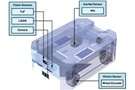
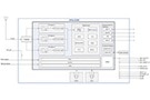
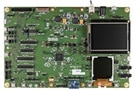
 Apply Advances in Sensing, Connectivity, and Motion Control Devices for Smarter Fixed-in-Place Robots
Publish Date: 2025-11-18
Apply Advances in Sensing, Connectivity, and Motion Control Devices for Smarter Fixed-in-Place Robots
Publish Date: 2025-11-18
Design precise yet flexible fixed-in-place robotics using advanced control, imaging, sensing, and communications technologies.
 Compact Multiband Patch Antenna Simplifies Design of RF Front-End for GNSS Receivers
Publish Date: 2025-10-23
Compact Multiband Patch Antenna Simplifies Design of RF Front-End for GNSS Receivers
Publish Date: 2025-10-23
To handle multiple satellite constellation frequency bands, a GNSS receiver employs a multiband antenna to realize higher accuracy and reliability.
 Enhance Autonomous Robot Localization Precision with Advanced IMUs and Sensor Fusion
Publish Date: 2025-10-01
Enhance Autonomous Robot Localization Precision with Advanced IMUs and Sensor Fusion
Publish Date: 2025-10-01
Combine advanced IMUs and other sensor types with sensor fusion for precise autonomous mobile robot (AMR) navigation in challenging environments.
 Use a Kit to Develop GNSS-based Precision Positioning Applications Quickly
A GNSS module and associated development resources offer a path to rapid deployment of centimeter-scale precision positioning in diverse applications.
 Antenna’s Innovative Materials and Design Solves the Multiband GNSS Dilemma
Use a compact dual-band (L1/L5) patch antenna for GNSS receivers to reduce size without compromising performance.
 Understanding The Role of Drivers, Switches, and Laser Diodes for Effective LiDAR Performance
Publish Date: 2025-02-06
Understanding The Role of Drivers, Switches, and Laser Diodes for Effective LiDAR Performance
Publish Date: 2025-02-06
Electro-optical components are at the core of LiDAR, which uses laser pulses to create a three-dimensional “point cloud” rendition of the surroundings.
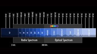 Fundamentals of Radar
Learn the essentials of radar, including the science of electromagnetic waves, the Doppler effect, and the impact of noise and interference on radar systems.
 What is LiDAR-Light Detection And Ranging?
Learn how LiDAR technology is used to measure distances with precision, and discover its applications in fields like autonomous vehicles and mapping.
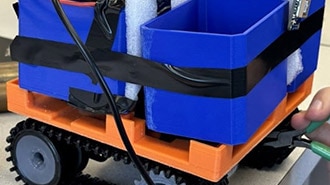 Robot Beehive Mover
Learn how a team of engineering students designed and built a robot beehive mover, complete with GPS, Bluetooth, and PCB design using OrCAD.
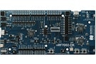
 Developing Edge AI Applications with ADI's MAX78002 MCU
Learn how the ADI 78002 MCU can support the design of edge AI applications with low power consumption, high performance, and robust security features.
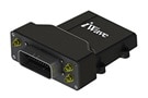 Lawn Mower Fleet Management with iWave Telematics Solutions
Publish Date: 2024-08-22
Lawn Mower Fleet Management with iWave Telematics Solutions
Publish Date: 2024-08-22
With telematics, lawn mowers can provide fleet managers solutions to monitor and manage their entire fleet, including vehicles, drivers, and assets.
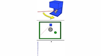
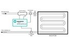 Integrated Time-to-Digital Converters Simplify Time-of-Flight Range-Finding Designs
Use integrated time-to-digital converters to simplify time-of-flight measurements for radar, lidar, sonar, and flow meters.
This robot allows one to build coding skills from a beginner's level to an advanced level. It allows hands-on experience and important problem-solving skills.
 Wi-Fi® Locationing Components Overcome GNSS, Cellular Gaps for Positioning Applications
Publish Date: 2024-08-07
Wi-Fi® Locationing Components Overcome GNSS, Cellular Gaps for Positioning Applications
Publish Date: 2024-08-07
Power-efficient Wi-Fi® companion ICs can overcome GNSS and cellular device performance limitations with high accuracy geographic positioning.
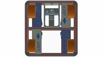 Enhancing XRP Functionality with a Mecanum Wheel Design
Learn how to build a Mecanum wheel frame for your XRP robot. Discover the design process, software setup, & assembly tips to enhance your robot's functionality.
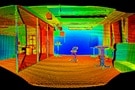
 SLAM from an Algorithmic Point of View (Part 2)
A discussion of the three primary techniques used in SLAM algorithms to create maps of unknown areas for robot navigation.
 SLAM: How Robots Navigate the Unknown Terrain
The concept of Simultaneous Localization and Mapping (SLAM) is discussed along with how to incorporate it into your application.
 Webinar – High-Precision GNSS for Smart Agriculture
Smart agriculture GNSS improves with resolutions reaching the centimeter level for position accuracy and Real-Time Kinematics which corrects common GNSS errors.
 How to Cost-Effectively Implement Reliable Aircraft Navigation Systems With Precision Components
Publish Date: 2024-04-11
How to Cost-Effectively Implement Reliable Aircraft Navigation Systems With Precision Components
Publish Date: 2024-04-11
Developers can use precision data acquisition modules and highly integrated IMUs to implement sophisticated and cost-effective avionics systems.